


Extreme weather the focus of day-long seminar
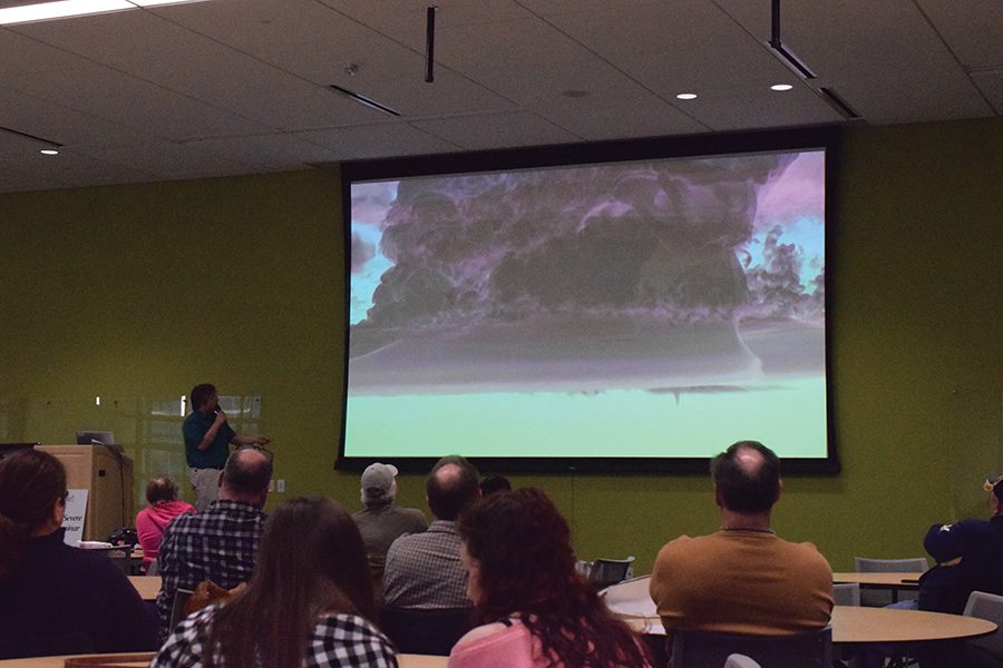
Participants in the Dark Skies Severe Weather Seminar view an image of a shelf cloud.
April 6, 2017
A sunny day begins to fade, but it’s only midday. An ominous cloud stretches from one end of the sky to the other, blotting out the sun, submerging the day into darkness. The once calm winds are now racing, much like the heartbeat of those facing the approaching storm. Rain pours, lightning cracks, and nature takes its unforgiving course.
Extreme weather is nothing new, but each day experts are working to further understand the science behind the storms. On March 25, Madison College hosted the annual Dark Skies Severe Weather Seminar. Storm chasers, scientists, and weather enthusiasts alike gathered in room D1630 for the day-long event that offered presentations for weather interests ranging from tornadoes and floods, to hurricanes and hail.
Dr. Matthew Lazzara, a Madison College instructor and part-time UW scientist for the Antarctic Meteorological Research Center, has worked hard to help make it all possible.
“It’s an opportunity to bring to the college community, and the broader community as well, to have folks be prepared, understand, and be able to protect themselves against these kinds of natural events,” he said.
The day began with a short opening ceremony followed by presentations from local Dane County Emergency Management as well as the Federal Emergency Management Agency (FEMA) about emergency preparedness.
“Instead of waiting, double checking, and then getting themselves into trouble, we want them to just be able to instantly take action,” states Lazzara.
Kelly Maddern then took the podium, describing her personal experience and survival of the 1996 Oakfield F5 tornado that devastated the rural Wisconsin town. An informative discussion led by American Family Insurance summed up the morning before the event recessed for lunch.
During the lunch break, the Madison College Geology Club held a fundraising event, serving pizza and assorted snacks. Meanwhile, attendees browsed surrounding informational tables and displays that were managed by participating groups.
Kids “wowed” alongside their parents as they watched weather visualizers. A group of storm chasers could be overheard recounting their adventures. “You never get used to the adrenaline rush,” one said. Another chaser even began passionately describing the movie “Twister” and its influence throughout his youth.
Upon reconvening, the National Weather Service (NWS) provided a Spotter Training Class that focused on teaching people how to properly identify storm features and report them to the NWS. A weather spotter, not to be confused with the adrenaline-fueled storm chaser, gives crucial eye witness verification to meteorologists, who can only “see” so much with radar. This is especially true when it comes to tornadoes. However important the information though, the primary emphasis is that safety comes first. The class segued in to a display by the Scary Looking Clouds Club, a group dedicated to cloud pictures, to further aid in storm identification.
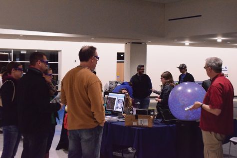
The day was nearing an end, but not before two last dazzling deliveries. Rick Kohrs of the UW-Madison Space Science and Engineering Center began by pulling a large electronic globe to the front of the conference room. Each member of the audience was offered a pair of 3-dimensional glasses before the lights dimmed and global weather patterns swirled brilliantly around the device. Kohrs completed the experience by providing background information on the satellites that make the imaging possible, and discussed the new GOES-16 satellite that was put into orbit last November.
Dr. Leigh Orf from the Cooperative Institute for Meteorological Satellite Systems (CIMSS) closed out the seminar with an array of psychedelic-looking tornado simulations, backed with a mixture of factual and theoretical science.
“He’s simulating things we would love to have visual evidence of,” Lazzara said.
The day concluded with a free-to-enter raffle. A handful of lucky winners took home various weather radios, detectors, and books as prizes.
Though there are many participants, this event is largely put on by the MidWest Severe Storm Tracking/Response Center. MidWest, a non-profit organization established in 1983, operates thanks to its volunteers that are dedicated to creating the best severe weather warning system in the area.
“They are a quiet, almost silent group if you will, in our community. They’re in our backyards doing this activity. They’re out there spotting the weather and getting it reported to those who can take action so people CAN be warned,” Lazzara said.
The group welcomes anyone with an interest in weather as well as those looking to get involved in storm spotter groups.
“After doing this for a day, folks appreciate it, and they’re able to incorporate it into their lives,” concludes Lazzara.
On Nov. 19, the National Oceanic and Atmospheric Administration (NOAA) launched the latest and greatest Geostationary Operational Environmental Satellite (GOES) in to orbit.
Geostationary satellites orbit around the equator in sync with the Earth’s rotation while polar orbiter satellites travel north to south. Combined, the two types of satellites provide full global scans.
Constant imagery and atmospheric measurements from the GOES-16 will vastly improve weather forecasts and storm predictions. Compared to the previous satellite of its kind, the GOES-16 has five times faster scanning, four times improved spatial resolution, and three times more spectral bands.
The satellite will even be capable of mapping lightning strikes, a game-changer for meteorologists. Imagery from the GOES-16 will be available this May.